|
Turkey Part 1
Gallipoli National Park and local areas
19 - 23 Sept 09
We spent two evenings in the Gallipoli National
Park and local areas.
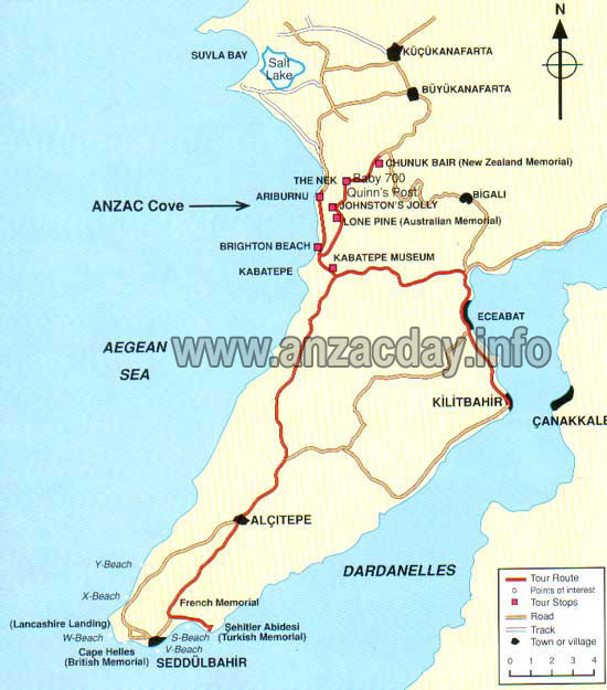
Eceabat is the closest town to the Gallipoli
Battlefields. With a population of approximately 4,500 people, and
originally a small fishing village known as Maydos on the shores of the
famous Dardanelles, Eceabat was shelled heavily during the
Gallipoli campaign of 1915.
It is a simple town and our 'otel', the 'Boss' is cheap
and located on the town square, just metres from the Dardanelle. We
frequent a coffee shop here each morning.
We pass through the fortress at Kilitbahir each day
heading to the battleground. Built in 1463
by Sultan Mehmet II, two fortresses
were built to guard the Dardanelles: Kale Sultanieh on the
Asian coast and Kilitbahir on the European one.
 Kilitbahir is an extraordinary fortress characterized
by a unique design: the sultan's architect worked with his compasses to
draw elaborate curved lines which perhaps explain the name given to the
fortress: Kilitbahir (Key of the Sea). A seven storey
tower/castle served both to accommodate the garrison and to have a high
observation point to identify enemy ships early. It has a triangular
shape, but the sides are the result of two convex lines. Kilitbahir is an extraordinary fortress characterized
by a unique design: the sultan's architect worked with his compasses to
draw elaborate curved lines which perhaps explain the name given to the
fortress: Kilitbahir (Key of the Sea). A seven storey
tower/castle served both to accommodate the garrison and to have a high
observation point to identify enemy ships early. It has a triangular
shape, but the sides are the result of two convex lines.
On the tip of the peninsula, in the old fort of Seddülbahir (Barrier of the Sea)
the Turks had only a small number of men and four old machine guns and for most of
the first day of the invasion, 25 April 1915, isolated pockets of Turks managed to pin the
British down and it was only under cover of darkness that the remaining
men on the invasion force could be landed. On the morning of 26
April 1915, a charge was led up from the beach and through Seddülbahir
village by Colonel Charles Doughty-Wylie. Force of numbers now pushed
the Turks back. Doughty-Wylie was killed and his grave, the only single
Allied grave outside a cemetery on Gallipoli, stands today just above
Seddülbahir.
To the north, Anzac Cove is a small cove noted for
the landing of the ANZAC (Australian and New Zealand Army Corps) on
April 25 1915. The cove is a mere 600m long, bounded by the headlands of
Ari Burnu to the north and Little Ari Burnu, known as Hell Spit, to the
south. Following the landing, the beach became the main base for the
ANZAC forces for the eight months of the Battle of Gallipoli.
ANZAC Cove was always within a kilometer of the
front-line, well within the range of Turkish artillery. General William
Birdwood, commander of ANZAC, made his headquarters in a gully
overlooking the cove.
The beach itself became an enormous supply dump and
two field hospitals were established, one at either end. Four floating
jetties were quickly constructed for the landing of stores, later
replaced in July by a permanent structure known as "Watson's Pier". The
volume of stores quickly overflowed onto the adjacent beaches; firstly
onto "Brighton Beach" to the south of the cove and later onto North
Beach beyond Ari Burnu.
Despite the shelling, ANZAC Cove was a popular
swimming beach for the soldiers — at ANZAC it was a struggle to supply
sufficient water for drinking so there was rarely any available for
washing. When swimming, most soldiers disregarded all but the fiercest
shelling rather than interrupt the one luxury available to them.
Concealed Turkish snipers also targeted swimming soldiers.
Over the years, ANZAC Cove beach has been degraded by
erosion, and the construction of the coast road from Gaba Tepe to Suvla,
originally started by Australian engineers just prior to the evacuation
of ANZAC in December 1915, resulted in the beach being further reduced
and bounded by a steep earth embankment.
click on a picture to see a larger
image. hit arrows at either end of the slideshow for more pictures.
Eceabat with our hotel on the right view from our coffeeshop: kids take the ferry to Çanakkale on the southern (Asian) coast of the Dardanelles (or Hellespont) for school our room with a questionable view Fortress at Kilitbahir. James and Renault rentaracer. looking northwest towards W Beach from the Helles War Memorial Seddulbahir....the old fort is off to the right of the photo V Beach CWGC....Seddulbahir fort and the Dardanelles in the background Sergi Yari Turkish cemetery Anzac Cove...invasion beach on 25 April. Close to 20,000 men land here on the first day: beach is 600m long and much lies under a new road Fishing boats...looking west into the Aegean. Imbros is the largest island of Turkey and is located at the entrance of Saros Bay Anzac Commemorative Site, beside Beach CWGC and below Ari Burnu (The Sphinx) Ari Burnu (The Sphinx) above ANZAC Commemorative site Ari Burnu on the left, scaled on the first day, with ANZAC Cemmemorative site and North Beach below North Beach, scene of additional landings Turkish monument at Chunuk Bair, a very bad place for ANZAC forces reconstructed turkish trenches at Chunuk Bair looking north along ANZAC lines to Suvla Bay to the north. Scimitar Ridge lies in the middleground Gallipoli House with Chunuk Bair in the background...from the turkish view of the battlebround ie inland James at Sulva Bay....his uncle lands here in Aug 1915. after swimming in Suvla Bay, l land on a sea urchin....l still have the spines in my left foot the only life in the area...semi feral cat l befriend in the fossilized mud flats alongside the beach looking north onto the Aegean...Imbros Island again in distance Scimitar Ridge: 15,000 english troops attack this ridge on 25 Aug...over 5000 casaulties by the end of the day, inlcuding Jim's uncle. l find a rum jar, carried by an english soldier, on Scimitar Ridge...it has been here over 94 years.

Eceabat with our hotel on the right
• Up • CWGC Cemeteries • Sidmouth • Gallipoli Natl Park • Helles Point/V Beach • Paracentrum • |

 coast of the Dardanelles (or Hellespont) for school")


")
 above ANZAC Commemorative site")


